It refers to physical arrangement of various structures like roads,shops,houses,markets,etc and distribution of various function inside the an urban area.
Empirical studies of few cities has resulted in 3 important models describing urban morphology.These are:
- Concentric Zone Model by E.W.Burgess.
- Wedge or sectoral model by Hoyt and Davies.
- Multi Nuclei model by Harris and Ullman.
CONCENTRIC ZONE MODEL
Burgess suggests a city grows outwards.Thus, morphology of urban area is concentric zones moving radially outward.He identifies 5 zones:
- Central Business District(CBD)
- Focal point of city’s commercial and cultural life
- Radially connected from all parts of cities making it most accessible place of city.
- Highest Concentration of commercial buildings,shops and business activities.
- Buildings are tallest in this part of city.
- Value of land is very high.
- Zone of Transition
- Zone of deteriorated buildings.
- Presence of slums.
- Light industries
- Low income group labours reside here who can’t afford transportation cost.
- Zone of workmen’s residence
- Workers and labours who move out of transition zone reside here.
- In india, these are generally planned housing area.
- Zone of better residence
- Middle class and higher middle class people reside in this zone which consist of businessmen, professionals, well played government employees, etc.
- Density and occupancy is very high.
- Commuter’s zone.
- These are smaller towns on the outside fringe of city from where people commute daily for mainly work.
- House are spacious with lawns and good space between two houses.
- Land cost is low.
Application
More applicable to pre-industrial revolution europe and unplanned cities.In India, it is
more applicable to smaller towns having population less than 1 lakh.
Criticism
- Circular shape of CBD is rarely observed. In general rectangular ,square and other shapes are observed.
- Over emphasis on trade and commercial activities and industrial land use has been neglected.
- Importance of large transport line has been undermined.Cost near roads are higher which has not been mentioned in this model.
- Topographical factors have been ignored which obstruct morphology to take concentric circular shape.

WEDGE OR SECTORAL MODEL
It was proposed by Hoy and Davies.Unlike previous model, this put emphasis on the role of transport line in determining the morphology and land use pattern of city.
According to it land use orients itself along the major transport line and thus, there is development of sectors instead of concentric circle.It suggests 5 sectors which are
- CBD
- light industries sector
- Low income residence sector
- Middle income residence sector
- High income residence sector.

Application
- Post industrial revolution europe
- In India, population more than 10 lakh.
MULTI NUCLEI MODEL
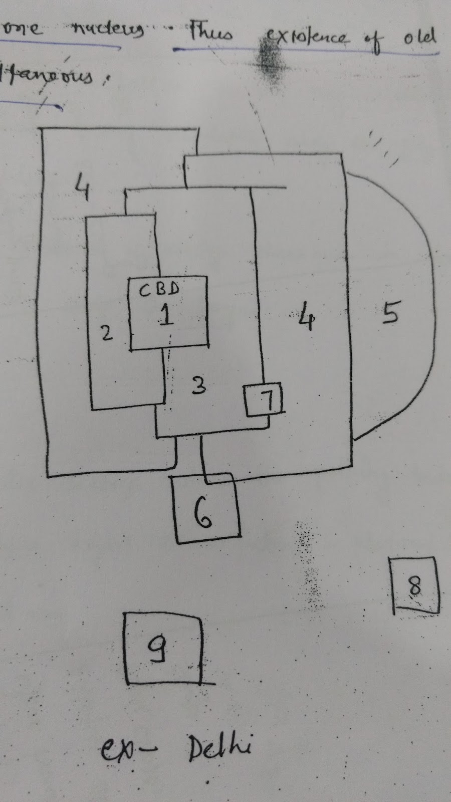
This model was given by Harris and Ullman.This model addresses shortcomings of previous concentric zone model and Sectoral model. This models fails to provide true picture of modern cities.
This model suggest that a city has multiple nuclei around which land use develops.Previously, only CBD was considered as one nucleus. It suggest multiple CBD can occur i.e old CBD and new CBD.Also heavy industries too can serve as neuclus around which land use pattern develops.
This model provides 9 zones in which city organises itself:
- Old CBD
- Zone of light industries
- Zone of low income housing
- Zone of middle income housing
- Zone of high income residence
- Heavy industries
- New CBD
- Residential sub-urban area
- Industrial Sub-urban area.
Comments
Post a Comment