Air Masses
DEFINITION
- An air mass may be defined as a large body of air whose physical properties, especially temperature,moisture content, and lapse rate, are more or less uniform horizontally for hundred of kilometers.
- Can be large enough to cover large section of a continent and vertical extent can reach up to tropopause.
- These are secondary circulation embedded in planetary wind system.
1.Homogenous and Extensive earth's surface.
2.Anticyclonic conditions
3.Stable weather conditions.
4 Stagnation for 7-8 days
CLASSIFICATIONS
CLASSIFICATIONS
- Two Fold Classifications
- Geographical Classification(Trewartha)
- Based on location of source:
- Polar(P), includes arctic
- Tropical(T), include equatorial.
- Based on underlying surface:
- Continental (c) and
- Maritime (m)
- Thermodynamic Classification
i) Cold(K)
ii) Warm(w)
iii)Stable (s)
iv) Unstable (u)
- Thus, total 4 geographical types are
i) Continental Polar (cP)
ii) Maritime Polar (mP)
iii)Continental Tropical (cT)
iv)Maritime Tropical (mT)
- Finally, we can have 16 types of air masses.
- However, there are 7 recognised type of air masses.
IMPACT ON WEATHER(Thermodynamic Modifications)
- factors
- Physical characteristics of air mass( temperature and moisture content)
- Nature of surface over which air mass pass
- Path taken by air mass
- time taken to reach destination
- Different cases
- Warm air mass pass over cold surface:
- Rise in temp;stability;may be foggy conditions;may be drizzle;low stratus clouds;
- Cold air mass pass over warm surface
- Drop in temp; instability; convection;precipitation depends on moisture;if high moisture then cumulonimbus clouds and heavy downpour ;if less moisture moisture then cumulus clouds and moderate rainfall.
 Air Fronts
DEFINITIONS AND CHARACTERISTICS- Air fronts refers to sloping boundary between two air masses having great contrast in physical properties like temperature,density,humidity & air pressure.
Process of formation of air fronts is known as frontogenesis, while process of destruction of front is referred as frontolysis.
- Fronts have diameter extending from 1600-3200 km along the latitude.
- Average slope varies from 1:100 to 1:300
- They may extend upto tropopause
- In winters they are more common because in higher latitudes winter time contrast is high.
- Physical Contrast:
- Air fronts forms between air masses with great contrasts in their physical
Properties like temperature, moisture content,lapse rate and pressure
- Circulation type:
- Relative motion of air masses or the circulation type must be favourable for
the formation of air fronts.
- Patterson has identified four types of air circulation- 1.Translatory circulation ,2.Rotatory circulation, 3.Convergent or divergent, 4.Deformatory circulation.
- According to him, deformatory motion is most favourable for frontogenesis.In this type of motion two contrasting air masses converge and instead of mixing, spread horizontally along axis of outflow or axis of dialation.The other axis in the direction of convergence of air masses is referred as axis of inflow.
Dig. of deformatory motion.
|
Process of formation.
- As air motion becomes parallel to axis of dilation, different types air fronts may occur.
- Stationary Front: If air masses are not invading invading in each others zone by lifting up or riding over other air mass, then such air mass is refered as Stationary front.
- Warm front: If warm air mass is active and invades the zone of cold air mass by riding over it, then warm front is formed.
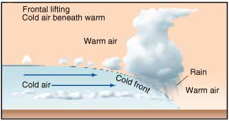
- Cold Front: If cold air mass is active and it invades the warm air mass zone by lifting the warm air mass then cold front is formed.
- Occluded front: if cold air mass invades the zone of warm air mass in such manner that whole air mass is uprooted from ground, then such air fronts are referred as occluded front.
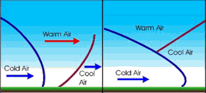
Fig: Occluded Air Front. .
- warm Front
- It forms as warm air mass rides over cold air mass.Common example is westerlies coming from south west direction invade the cold air mass embedded in polar easterlies
- Slope is gentle which varies from 1:100 to 1:400
- Air rising above cold front are cooled adiabatically and nimbo stratus(horizontal cloud) cloud formation occurs
- Associate with gentle to moderate precipitation over longer period and larger region
- Cold Front
- Cold air mass being denser remain close to ground and lift the warm air mass.Common example is more active polar easterlies invades warm air embedded in westerlies.
- Its slopes are steeper than warm air mass as the air close to ground are slow moving due to friction while the upper section has greater speed due to absence of friction. They develop a convex surface due this velocity difference.Slope generally varies from 1:50 to 1:100
Comments
Post a Comment